
* Entries include: aviation infrastructure, road trips, the fall of the hunter-gatherers, Nabaztag smart bunnies, Virgin's SpaceShipTwo commercial spacecraft, smart TV systems in stores, Lawrence Lessig, crash-test dummies, smart car electronic systems, crewed mission to an asteroid, Toyota problems, & Blu-Ray wins the super-DVD wars.

* NEWS COMMENTARY FOR FEBRUARY 2008: The big international news for February was that the ailing Fidel Castro finally announced his retirement as boss of Cuba after almost 50 years in leadership. However poor his health is, he can at least have the satisfaction of having outlived most of the American presidents who opposed his regime, sometimes with "extreme prejudice". His little brother Raul -- at 76 years old, hardly a youngster -- has taken his place, and has announced that "structural and conceptual" changes in the way things are done may be required.
Stateside, John McCain effectively clinched the Republican nomination for the presidential race. Mike Huckabee continued to campaign even though there was no real chance that he could win; it appears that he was laying groundwork for another shot at the nomination in four years' time. On the Democrat side, Hillary Clinton and Barack Obama engaged in an exhausting struggle to get a nose ahead of each other -- it's been a long time since a primary race went on this long without resulting in a winner. It is expected that primaries on 4 March will settle the Democrat nomination.
* In one particularly interesting bit of news, after nationalizing foreign oil companies operating in Venezuela in 2007, Venezuelan strongman Hugo Chavez found out the oil companies can bite back. Exxon Mobil took the Venezuelan government -- more specifically the national oil company, Petroleos De Venezuela SA (PVDSA) -- to court in the US, the UK, the Netherlands, and the Dutch Antilles to freeze about $12 billion USD of PVDSA assets until an international court can rule on Exxon Mobil's claims. International courts don't operate at any breakneck rate of speed, and Chavez hasn't been happy about the matter.
However, Hugo Chavez isn't the only one getting nicked -- the European Commission hit Microsoft with a $1.4 billion USD fine for anticompetitive business practices. Back here stateside, nobody is gloating too much over Microsoft's misfortune, since there's plenty of economic misery to go around: the housing market is stagnant, gas prices are at a record high, food is hitting record highs as well, and the result is "stagflation", that perverse phenomenon where inflation is taking place even when the economy is becalmed.
BACK_TO_TOP* GIMMICKS & GADGETS: I was poking around evolutionary websites and ran into an article that parodied creationist rhetoric by mocking the idea that humans can actually fly. The article featured pictures of ridiculously impractical early aircraft designs, as well as a parachutist in an old flying helmet and wearing a set of batman-type wings.
The picture of the guy with the wings brought back an old memory -- he hadn't been trying to fly as such, he was what would now be called a skydiver who used the wings to maneuver a bit and slow down his terminal velocity. According to the Wikipedia article on "Wingsuit Flying", the practice began in the 1930s, but most of its early enthusiasts eventually "bounced", as skydivers quaintly put it. The American daredevil Clem Sohn, known as "The Batman" for his outfit, was killed in 1937, while Frenchman Leo Valentin was similarly killed in 1936.
It seemed the idea wasn't entirely ridiculous, but it had some safety hazards, the suits having a deadly tendency to interfere with parachute deployment. It was left to another French skydiver, Patrick de Gayardon, to come up with a better "wingsuit", though he himself was killed in 1998 due to a parachute rigging error. That same year, a Finn named Jari Kuosma and a Croatian named Robert Pecnik came up with a definitive wingsuit design. They took a much more conservative approach than the early, dangerously clumsy implementations, with a suit featuring flaps of cloth under the arms and between the legs. They founded a company named Birdman INC to sell the suits, and very importantly established training courses on how to use them safely.
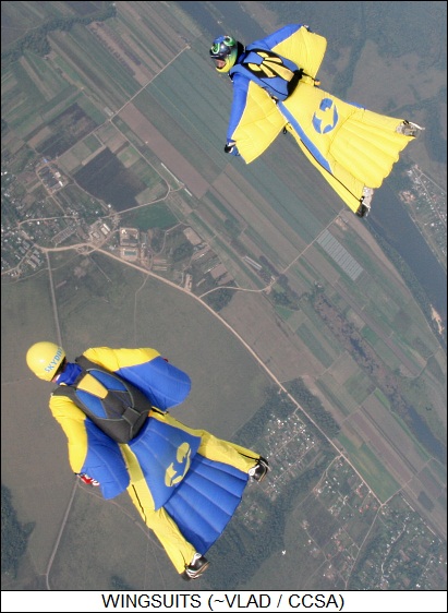
Other companies have since jumped into the wingsuit business -- they're also called "birdman suits" or "squirrel suits", the last it seems because they suggest a flying squirrel. The sport is catching on, because a wingsuit gives a skydiver an enhanced feel of flying like a bird. A wingsuit can cut terminal velocity almost in half and provide a glide ratio of 2.5:1 -- that is, for every one meter of drop the jumper can get up to 2.5 meters of horizontal travel. Once the jumper's chute opens, the wings can be unzipped so they don't inhibit the jumper's movements as much. As mentioned previously in these pages, some vendors have also developed hard plastic "wingpacks" to get pretty much the same effect, and have even incorporated small jet engines into them to improve the glide ratio.
* POPULAR SCIENCE had an article on a neat little system of gadgets built by a company named BUG Labs. The BUG system is built around a pocket-sized Linux-based computer, the BUG base, in the form of a white high-impact plastic slab. There are four ports on the faces of the slab to allow up to four other modules to be clipped on. Current modules include a motion sensor, a GPS receiver, an LCD display, and a digital camera; the company is working on other modules, such as solar panel and a digital TV tuner.
The immediate reaction is: "Gee, that's cute. What good is it?" The idea of mixing and matching pieces of a pocket consumer electronic system sounds like fun, but not really all that practical. However, consumers aren't really the target market for the BUG system, the technology instead being focused on developers who need to put together pocket systems for particular applications on a fast-track basis. They can develop their own modules to complement those sold by BUG Labs, and then program the BUG base to integrate modules.
* BBC.com had a report on an interesting gadget put together by British designer Andrew Fentem. The device, the "Fentix Cube", doesn't look like much on the outside, appearing as little more than a small plastic cube containing an array of LEDs powered by a battery. However, it's considerably smarter than an idiot toy with flashing lights: the cube contains three-axis accelerometers, allowing it to track its own motion, and its surfaces contain touch sensors, making it a highly interactive user-interface device.
As a demonstration, Fentem programmed the Cube to play some simple games, including a Pacman-like maze game. He sees it as much more capable than that, particularly if it had a wireless interface, allowing it to be used for applications along the lines of those developed for the Nintendo Wii wand. Nobody's snapped up production rights yet, but Fentem is undiscouraged: "I'd like the cube to go mass market. I'd like to see it in people's homes. But if it only serves as an introduction to my work, I'll be happy."
BACK_TO_TOP* THE PRICE OF CIVILIZATION: An article in THE ECONOMIST ("Noble Or Savage?", 22 December 2007) took a closeup of humanity's past as a hunter-gatherer species and at the transition to a primarily agricultural species. Humans started out as hunter-gatherers, the men killing animals for food while the women simultaneously scrounged for fruits, edible roots, acorns, and the like. Although some hunter-gatherer groups still persist, they're a tiny minority; about 12,000 years ago, humans began to farm the lands, and gradually the farmers drove the hunter-gatherers almost completely out of business.
This might be seen as progress, but Jared Diamond, an evolutionary biologist and professor of geology at the University of California / Los Angeles, once called it "the worst mistake in the history of the human race." Why? Because it led to protein and vitamin deficiencies, new diseases, and deforestation. The transition to agriculture was marked by an average reduction of 15 centimeters (6 inches) in average height of adult males.
About 15,000 years ago, the hunter-gatherer cultures were fairly sophisticated. They had spear throwers, boats, needles, nets; they painted pictures, they prepared herbal medicines, they engaged in trade. It might not have been such a hard life; some anthropologists claim that modern hunter-gatherers actually "work" maybe about two days a week, and they have a surprisingly healthy diet. The problem with the hunter-gatherer lifestyle, however, was that it was highly dependent on the cooperation of nature. If climate changed, herds of prey might dry up and pickings could get slim.
That's what happened about 13,000 years ago, at the beginning of a thousand-year cooling trend known as the "Younger Dryas". Given a changing climate, hunter-gatherers were presented with increasingly uncertain food supplies. The answer, learned in a number of locations around the globe towards the end of that tough millennium, was straightforward: plant seeds instead of simply eating them and live off the crop. Keeping herds of animals was the next step. If the food supply was uncertain, then survival depended on human control of the food supply instead of simply relying on nature to be bountiful. That meant, however, a less varied diet, resulting in poorer health. It also meant a less egalitarian society: hunter-gatherer tribes tend to be socially easy-going, but agriculture requires labor, leading towards a drive to acquire servants and slaves. As irrigation systems became more common to ensure crops, states began to emerge -- possibly cooperative in nature, though it seems a better bet that they tended towards the despotic.
* So was the shift to agriculture really a fall from grace? Some scholars think not. Modern hunter-gatherer tribes tend to fight among each other a good deal, with adult males having a high probability of dying from violence. Some suggest that this is a modern anomaly, that there's nothing inherently violent about hunter-gatherer cultures, but there are logical difficulties with that point of view. In modern times, hunter-gatherers are few in number and live in regions where there isn't much competition for resources. One of the features of a hunter-gatherer lifestyle is that it cannot support high population densities: the tribesmen have to live off whatever nature provides, and once even modest crowding starts, the result is a turf war, aggravated by the inclination to steal females from other tribes. When hunter-gatherers were the norm, competition could get tough, and hunters might have had to range farther in search of prey -- while being forced to fight it out with other tribes.
A simple farming society can support a hundred times more people on a given amount of land than a hunter-gatherer society, and the farmers don't generally live in continuous fear of being murdered by the farmers living down the road. The fact that general health was worse in early farming societies may have been more an indication of the benefits of the life than its limitations: the members of hunter-gatherer societies were healthier because the tribesmen who weren't so healthy were killed off.
There are interesting parallels between the agricultural revolution and the industrial revolution. Descriptions of the early days of industrialization, before and after the beginning of the 19th century, tend to be horrific tales of "dark satanic mills" and urban squalor, but with rising populations the countrysides were worse, suffering poverty and ghastly bouts of starvation in lean years. Even today, in developing countries people abandon the farm to slave away in dirty factories and live in pesthole slums -- it might be a lousy living, but they find it preferable to going hungry.
* The notion that humans lived in a tidy "balance of nature" before the agricultural revolution also isn't getting much respect these days. Richard Dawkins likes to lampoon the entire idea of a "balance of nature" as a Panglossian read on a rougher reality, pointing out that in Darwinian terms nature is competitive, with different species striving to get the upper hand. When there's a balance, it's more like a "balance of power" than natural harmony, since the system has tendencies toward instability. Upset the balance of power, extinctions result.
The spread of human hunter-gatherers around the globe seems to have been followed by the extermination of large birds and mammals. Bonepits left by ancient hunter-gatherer tribes show they preferred to kill the bigger animals, since they gave the most return for the effort. It wasn't until the big animals got scarce that the hunter-gatherers turned to smaller species -- rabbits and smaller antelopes -- that bred fast enough to make them harder to kill off completely.
The bottom line is that the Earth had never seen another species like humans before, capable of harnessing technologies, and almost from the outset humans upset the status quo. Ultimately, the hunter-gathering culture ran into diminishing returns and a struggle for survival, leading to the innovation of agriculture. When agriculture ran into diminishing returns, it led to the innovation of the industrial revolution; and in modern times we can see global warming as presenting a challenge in turn to modern industrial culture, leading to another revolution -- though this one is ongoing, and its end results are not easy to predict.
BACK_TO_TOP* SMART BUNNIES: An article on BBC.com ("Smart Tags Hail The Web Of Things" by Mark Ward) discussed several of the latest tricks in RFID technology, focusing in particular on the "Nabaztag Bunny", which is a wi-fi-enabled toy plastic bunny that can be programmed to play MP3 music files, provide wakeup alarms, recite emails, stock quotes, weather, or anything the user wants to program it to read off.
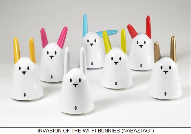
Now Violet of France, the manufacturer of the Nabaztag, is fitting the bunny with an RFID reader. In itself, that wouldn't seem to be much of a feature, but Violet is working with book publishers to set up internet-accessible audio files keyed to the RFID tag for a book. Wave the book under the bunny's nose, it "sniffs" a code out of the tag, goes out on the internet, grabs the appropriate audio file for the book, and then starts reading it out. The user can move back and forth through the audio file by, of course, moving the bunny's ears. If the reading is halted, the bunny will remember where it left off so it can start up again later.
This sounds halfway silly and halfway promising. Jean-Francois Kitten, a spokesman for Violet emphasized the potential of the concept: "In the average house you have about 10,000 different objects and right now you have maybe three objects connected to the net -- phone, computer and perhaps a rabbit. But we think that more and more objects are going to be connected."
To Violet's way of thinking, an RFID code can be regarded as an address of an online resource that can perform any desired action when accessed by that code. Violet is working towards the day of total connectivity by developing stick-on "RFID stamps", what they call "Ztamps", that can be stuck on any object, and used to key a user-programmed action when the object is waved under the nose of the RFID-enabled bunny. Says Kitten: "The future of the internet is an internet of connected objects."
[As seen from 2018, the Nazbatag Bunny was an ancestor of the now increasingly-ubiquitous smart speaker -- if cutesier and with a slightly different use model. I suppose we'll see smart speakers playing the cutesy card in the future. Now to return to ED comments from 2008:]
I recently finished a fun anime video series called CHOBITS -- sort of a sci-fi romantic comedy / sex farce / soap in a future Tokyo that rotated around "persocoms", which were interesting hybrids of androids and personal computers. They could perform simple physical tasks, like handling a cash register, or they could be used to perform internet access, make and receive wireless phone calls, take still pictures and videos, and the like. The Nabaztag BUnny suggests this idea may not be so far out as it might seem.
Persocoms were stereotypically full-sized, but one of the characters, Shinbo, had a pocket persocom named Sumomo ("Plum"), with the looks of a little girl about big enough to sit comfortably in a coffee cup, with violet hair and dressed in little-girlish genie clothes. Shinbo didn't own a full-size persocom, finding a "laptop" like Sumomo more practical since he didn't have to pay an extra fare to bring her onto a train. There were also cheap "PDA" or "keychain" persocoms that could handle phone calls and the like.
Sumomo had a little display interface panel that she could hold in her hands like a placard, though she didn't use it much since her normal interface was voice-in / voice-out. She wore something that resembled a pillbox hat where her video and datalink interface cables were stowed, though usually she communicated via wireless. When she got a phone call or email, she'd shake a little tambourine and cry out: "You have mail!" -- or: "You have a phone call!" When she got a phone call, Shinbo would simply converse with her, with Sumomo talking in the speaker's voice as an "avatar" of the person on the other end of the line.
When idled, Sumomo would go into "screensaver mode", in which she'd put on a little dance. When powered-down, she'd curl up and go to sleep. Shinbo set her with a wakeup alarm, and at the proper time she would wake up, blow a shrill little police whistle, and direct a session of wakeup exercises. She also had navigation capabilities and could provide directions: "Turn left at the next intersection."

The hero of the series, Hideki, was a likeable but technically illiterate "hick from Hokkaido" -- the northern main Japanese island, generally regarded as "the sticks". He dropped Sumomo on a live wire and, to his panic, knocked her out of operation. Fortunately, all Shinbo had to do was reboot her, with Shinbo telling Hideki: "You're lucky, if you had damaged her memory it might have been expensive to replace."
"How expensive?"
"Sumomo, check the internet and get prices for your memory module."
She replied: "Affirmative. Scanning ... " After a moment she says: "Found ten items. Would you like me to print them out?"
Shinbo set a pad of paper and a pencil on the desktop and told her: "Go ahead, please." She picked up the pencil, which was taller than she was, with both hands and stepped onto the pad, writing line by line. Hideki asked: "Couldn't you hook her up to a printer?"
Shinbo replied: "I could, but it's cuter this way."
BACK_TO_TOP* BAY AREA ROAD TRIP (2): I left Spokane after dinner on Tuesday evening, 9 October, to spend the night in Tri-Cities / Kennewick, down on the bend of the Columbia River in the deserts near the Hanford nuclear site, where they built the first plutonium breeder reactors during the war. That put Portland within easy driving distance Wednesday morning.
The land tends toward the treeless and desolate passing through that region -- no, despite its reputation not all of Washington State is damp and rainy. Once the sun goes down it's a slightly eerie drive down the highway, the kind of place where it would seem appropriate to be rolling down the road in the dark and have a UFO spin past in the other lane, with incidental music from CLOSE ENCOUNTERS OF THE THIRD KIND playing in the background. Of course I've never really had that experience and don't honestly expect to, but in a place like that it would seem that it could happen.
I was intimidated by navigating to the Kennewick Super-8 at night because it involved switching between three different highways, but though I got to thinking "I'm lost" more than once, it turned out that I didn't miss a step. Planning pays. The Super-8 had the nice distinction of having chocolate chip cookies -- good ones -- set out for evening visitors.
* The next morning, Wednesday, 10 October, I got back on the road to go over the Columbia into Oregon. When I got into Oregon the signs read: SPEED LIMIT 60 MPH / MANDATORY HELMET LAW / MANDATORY SEAT-BELT LAW / WELCOME TO OREGON. Ah, yes, the Oregon I used to know when I lived there in the 1980s. Oregon has sort of a "politically correct" reputation -- I'll say no more since it's all old history, and I avoid the culture wars. I do have to add that when I left Oregon almost two decades ago and went to Colorado, I had to laugh to see the typical bumper sticker change from THINK LOCALLY ACT GLOBALLY to MEMBER NRA.
The drive along the south bank of the Columbia is actually fairly photogenic, and I was able to pick up some interesting infrastructure pix: a lift bridge, river barges and towboats, and a very-high-voltage powerline with triplicated conductors. The last I could have found elsewhere easily enough, but I'd been wanting to add it to my picture collection. I made good time to the Portland Zoo without any difficulties. I hadn't visited since the late 1980s and much had changed. It was rainy and became more rainy as I walked about -- ah yes, this is the Oregon I remember.
I took off in the rain to go to the Evergreen Air Museum in McMinnville to the southwest. It's where the big Hughes Spruce Goose flying boat resides. I'd also been there before and got some good pix then; I was just dropping by to check for additions and maybe opportunities to also get shots under different conditions. Actually, it turned out to be a very worthwhile stop, since the museum had been expanded considerably since my last visit. They had a set of new outdoor displays including a Northrop F-5E Tiger II, a Mikoyan MiG-29, a Lockheed Neptune fire bomber, all in very nice and photogenic condition.
I had thought to visit the aquarium in Newport, on the coast, but had figured it was too far out of my way. However, on checking the map I realized that McMinnville was a good step of the way to the coast, and there was no reason not to keep on going -- once I got out of McMinnville navigation would be easy, just take state 18 to the coast, where I was familiar with the roads.
My major objective was the puffin-awk exhibit, which I had seen in the late 1980s. That proved to be a bust even though the exhibit had been greatly expanded into a very nice walk-through aviary; the problem was that the birds were in their winter colors, and weren't as interesting a photographic subject as they were in their mating plumage. Oh well. However, the aquarium did have an extensive and well-laid-out "fish tank" section that made up for that disappointment. One of the staffers started giving me an informal tour and I was able to surprise her with a degree of knowledgeableness: "Those are hagfish, right?" Ugly little eel-like scavengers ... we chatted about comb jellies and the like. Anyway, I got a few good pix of anemones and so on.
I left the aquarium when it closed at 5:00 PM. I drove down to the shoreline to get pix of the Yaquina Bay Bridge, which is a particularly attractive steel arch structure that I was glad to get into my collection. From the arc-deco obelisks on the bridge ramp it looked like a Depression-era works project.
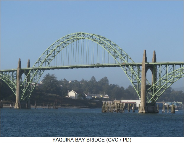
I later checked out Wikipedia -- once again, whatever Wikipedia's limitations, it's a good bet that it will have information on obscure topics like this -- and found out it had been opened in 1936, being designed by Conde McCulloch, an Oregon engineer who worked for the state department of transportation and designed many of the bridges along the US-101 coast highway. His bridge designs are highly regarded, and from what I could judge with very good reason. Interestingly, he was also a professor at my "alma mater", Oregon State University -- AKA Beaver State University, home of the mighty Beavers.
I drove back inland towards I-5 through the hills and forests, with the sun shining through a blue sky interrupted by clouds, feeling some satisfaction at the way the day had gone. Unfortunately, that took me back through my old home of Corvallis, where I'd got my college degree and worked for about a decade. I should have gone down the coast to Florence and turned inland there, even though it would have been more troublesome, because as I drove past familiar sights I got a real case of the creeps. I was bumbling things in the days I lived there, and it brought back a lot of unpleasant memories I had otherwise forgotten. I couldn't get out of that town fast enough.
I had time to get a good meal in Eugene and thought I'd find an Outback steakhouse -- my idea of a high-class meal, incidentally. I figured I'd be able to find one just by cruising down the freeway and checking the signs, but I'd forgotten, if I'd ever known, that Eugene is essentially well off of I-5. I did a dogleg on a spur freeway into town but soon realized that this was not going to take me anywhere. I didn't get lost, I just backtracked the way I came, in the meantime considering the fact that just driving around to find a particular restaurant -- except for a McDonald's or a Subway, that's easy -- was like hunting for a needle in a haystack. To hammer in this lesson, when I got to the Super 8, an Outback was almost next door. [TO BE CONTINUED]
START | PREV | NEXT* INFRASTRUCTURE -- AVIATION (7): A few miscellaneous comments will tie up the discussion of airports. While helicopters often operate out of public airports, since they can be operated out of any open flat space, they also often fly out of "heliports". All a heliport amounts to is a concrete pad surrounded by a fence, though sometimes they're on top of buildings. The area around the heliport is zoned to ensure the takeoff & landing path is clear of tall obstructions. There will usually be a wind sock to tell the pilot which way the wind is blowing.
Typically a ground heliport will have a "H" marked in the middle; a hospital heliport may have a white cross with an "H" in the center. Heliports on the top of buildings have a circle with a number in the middle, the number giving the maximum weight of the helicopter in thousands of pounds. It is possible to find heliports listed in directories of municipal airports, but it would be incorrect to think that heliports are necessarily busy installations like a municipal airport. They may only service one or a few helicopters for a hospital or a TV station; they may not even normally operate helicopters at all, being merely a place where a helicopter can land, but only does so occasionally.
* There are also a lot of airports, particularly out in the country, that don't have much in the way of high-tech gear, no control tower, and in fact may have a grass landing strip. They provide a home for small civil aircraft and crop-dusters. An aircraft usually flies up the side of the airstrip to check for other aircraft and then does a U-turn to land. If the airport has more than one runway, there will be a segmented circle -- painted on the pavement or marked with white stones -- about 30 meters (100 feet) in diameter at the intersection of the runways. There will be a wind sock or even an arrow marker at the center of the circle to indicate which runway is active, in accordance with the prevailing winds. Despite the informality, there's nothing particularly unsafe about such little airports. Their traffic load is light, the aircraft are low performance, and the interactions between the pilots generally neighborly.
* One last item: in the USA, the Federal Aviation Administration insists that tall structures be marked, either by being painted in a red and white checkerboard, or with a flashing warning light, or both -- though really big structures like skyscrapers aren't required to sport the gaudy paint job, the idea being that they are visible enough already. The height of the structure that demands marking runs at about 60 meters (200 feet), though it gets progressively lower as distance to an airport decreases. Antenna masts will have strobing lights up their height. Cables strung across rivers and the like will also have markers of whatever sort to prevent collisions with low-flying aircraft. [END OF SET 11]
START | PREV | NEXT* SPACESHIPTWO: In 2004, Burt Rutan's Scaled Composites company won the Kremer X-Prize by performing the first crewed space flight in a purely civil spacecraft. The flight was performed by the "SpaceShipOne (SS1)" vehicle, which was a small spaceplane powered by a "hybrid" rocket engine, using rubber and laughing gas as propellants. SS1 featured an unusual "shuttlecock" wing system, with the wings hinging upward to give the vehicle the proper orientation for reentry. It was hauled to altitude for launch by a carrier vehicle, the "White Knight One (WK1)", which was a twin-boom aircraft powered by twin turbofan engines, with the SS1 carried on the wing section between the fuselages.
The project had been funded by Paul Allen of Microsoft, who didn't have any further plans for the system after it won the X-Prize. However, the exercise attracted the interest of Sir Richard Branson of Virgin Enterprises, who funded a follow-on system to take paying passengers on suborbital jaunts. Branson recently unveiled a model of the Virgin Galactic / Scaled Composites "SpaceShipTwo (SS2)" along with its carrier aircraft, the "White Knight Two (WK2)", and stated it would take its first fare-paying passengers on flights beginning in 2010.
SS2 will carry two crew and six passengers on jaunts lasting about 150 minutes, reaching a maximum altitude of 110 kilometers (68 miles) after launch from WK2 at an altitude of 15,250 meters (50,000 feet). SS2 and WK2 are basically scaled-up derivatives of the SS1 and WK1, with both made of carbon composite materials:
Virgin Galactic is funding five SS2s and two WK2s. Each SS2 could fly twice a day, with each WK2 flying three or four times. Tickets for a trip will cost $200,000 USD, with more than 200 bookings so far and tens of thousands of inquiries. The flights performed from a new facility titled "Spaceport America" in the New Mexico deserts. Branson says the system would also be made available to industrial and research groups. WK1 has already been used to launch hypersonic research aircraft, and the US National Aeronautics & Space Administration (NASA) has an agreement with Virgin Galactic on use of the company's space vehicles.

Concepts are being investigated in which the WK2 would carry a space launch vehicle instead of the SS2 to put satellites in the weight range of 50 to 100 kilograms (110 to 200 pounds) into orbit. Launch costs would run about $2.5 million USD -- a real bargain compared to existing launch vehicles. Almost any airport could be used as a launch site, and the carrier vehicle could fly to locations matching the proper "launch window" for the satellite. In fact, Rutan thinks he will end up building more WK2s for satellite launch than for space tourism. Over the long run, Branson and Rutan would like to develop a commercial space vehicle that could fly into orbit itself, though this is regarded as a much bigger challenge than merely performing a suborbital hop.
BACK_TO_TOP* BIG GROCER IS WATCHING YOU: An article run here back in November 2006 on store video camera security systems described how smart they had become in catching thieves. As reported in an article in THE ECONOMIST ("Watching As You Shop", 8 December 2007), somewhat surprisingly it turns out that store surveillance systems are also keeping an eye on the honest customers to see how they shop.
British supermarket giant Tesco, for example, has implemented a system called "SmartLane" in its stores that ensures clerks are called to the checkout aisles in response to customer load. SmartLane, developed by Irisys of the UK, features sensors at the doors of the store to count how many customers have entered and how many have left, and sensors at the tills to see how fast transactions are being handled and how many "shopping units" -- groups of people, such as couples or a parent and kids, who only make one transaction per group -- are in each queue. Figuring out the "shopping units" is a bit tricky; it involves an infrared scanner that merely tracks customers as thermal "blobs" and algorithmically determined if they belong to a single group or not. The algorithm is right 19 times out of 20. In any case, a central processor takes all the inputs and pumps them through a model to determine which checkout queues should be opened.
Similar systems are now in use in other chains of stores in the UK and the US. Some go a few steps further. Office Depot and Toys"R"Us use a system based on double-lens cameras produced by Brickstream, a manufacturer of customer-monitoring systems. The cameras are merely the "eyes" of a sophisticated Brickstream system named "BehaviorIQ" that analyzes the movements of customers, how long they pause in different places, and how they react to various products. This information can be matched to transaction logs to evaluate the effectiveness of store layout, product displays, and so on. The American consumer-electronics chain Best Buy used the Brickstream BehaviorIQ system to determine that the stores had five types of shoppers: young technology enthusiasts, suburban mothers, affluent early adopters, family men, and small-business owners. The result was that Best Buy stores were divided into five sections, one for each customer group.
One of the most ambitious "customer surveillance" efforts performed so far is the "Pioneering Research for an In-store Metric (PRISM)" system, implemented by a collaboration between the market-research firm Nielsen Media; the Chicago-based Instore Marketing Institute; and various businesses, including Coca-Cola, Proctor & Gamble, and Walmart. PRISM has been implemented in 160 stores and features sensors at the doors of the store as well as in the aisles. Human observers complemented the sensor inputs to obtain insights into shopper behavior. For example, when customers visited the salty-snacks aisle, they bought something two-thirds of the time; there was no such compulsion at the dairy aisle. Parents accompanied by children bought more food, with purchase of seasonal items being 2.5 times as likely, though oddly the presence of children did not mean more purchase of sweets. PRISM data demonstrated that a lot of the ideas that retailers had about customer behavior were superstition.
Even more information can be extracted from customer surveillance systems. VideoMining, a spinoff from Pennsylvania State University, uses video camera footage and software to not only analyze customer behavior, but also determine the age, sex, and ethnicity of customers with an accuracy of about 80%. This sort of data can help a store target its sales to appropriate markets.
Store surveillance certainly raises privacy issues, but then few people consider shopping a private experience, and those working on the systems avoid logging data on specific individuals since it's obvious that would lead to legal troubles. Customers usually don't mind having data collected that makes shopping more convenient and targeted to their needs.
However, customer speech is starting to be recorded as well. An Atlanta-based company named Recordant now sells digital audio recorders that store clerks wear around their necks to record conversations with customers; the contents of the recorders are downloaded to a system at the end of a shift, with the conversations scanned for particular words and phrases. One retailer using the Recordant system was able to show that there was a 300% increase in sales of products recommended by shop clerks. The system allows retailers to improve training and evaluate the effectiveness of product promotions. Of course, recording customer conversations is unarguably intrusive, and so the digital-audio recorders have a bright display to tell customers that they are being recorded. There has been some unease among both customers and staff over the use of the recorders, though the recorders can help staff who have been unjustly accused of wrongdoing by quarrelsome customers.
It might seem that customer surveillance systems are pushing the thin edge of utility. The fact is that retailers are often getting by on the thin edge of profitability in the first place, particularly when competition from online vendors is factored in. Any small edge the retailers can get can translate into big profits, and retailers find the surveillance system worth every penny.
BACK_TO_TOP* LAWRENCE LESSIG FIGHTS BACK: Anybody who has ever read up much on copyright issues in the USA knows about law professor Lawrence Lessig, who has been tireless if not entirely successful in his resistance to the creeping stranglehold of American copyright law. An article in THE ECONOMIST ("Cyberlawyer 2.0", 8 December 2007), took an interesting closeup on Lessig.
In the early 1990s, Lessig made his first linkage between cybertechnology and the law when he was a legal clerk at the Supreme Court. The court had been using an old mainframe system to send out rulings, but Lessig and a colleague found it way behind the times. They made a pitch to the court's technology committee and the chairperson, Justice Sandra Day O'Connor, immediately ordered PCs for the organization.
These days Lessig, now 46 years old and faculty at Stanford Law School in California, is one of the major figures in the domain of cybertech and the law. He founded the school's Center for Internet & Technology; is a board member of the Electronic Frontier Foundation, an internet lobby group; and is one of the prime movers behind Creative Commons, a nonprofit organization that promotes a limited form of copyrighting licensing that promotes sharing of creative work. He is also an energetic blogger who is very good about spreading his ideas.
These days, having spent ten years fighting the battle over copyright protection and the internet, he has changed tactics somewhat, announcing that he was focusing on government corruption. That confused some of his fans, but it was perfectly logical: having been fighting a losing battle against the relentless spread of copyright protection, he now believes that it's not the laws that are broken, it's the system itself, that lawmakers are so under the thumb of big-media lobbyists that they either do not know or do not care that there are good reasons to oppose indefinite extensions of copyrights. Lessig points out that the US Congress has extended copyright protection 11 times over the past four decades. He sees this same pattern of one-sided influence in other domains of government as well.
Lessig is not any stereotype of a cyberpunk radical. He started out tinkering with electronics in high school, but his real love from the outset was the law. His uncle, Richard Cates, the associated special general counsel to the House Judiciary Committee during Richard Nixon's impeachment hearings, told Lessig that the law was the only place where reason controls power. Lessig took the comment to heart and still believes it. Still a church-going Protestant, Lessig was once a Republican activist, though these days he's a member of the American Civil Liberties Union, cites Al Gore, and grumbles about the Bush II Administration's overreach of the authority of the presidency.
Lessig studied economics and management at the University of Pennsylvania in Philadelphia, went on to study philosophy at Cambridge University in the UK, then returned to get a law degree at Yale. After a stint as a clerk in the Federal court system, he became a professor specializing in "cyberlaw", working at the University of Chicago, Yale, and Harvard before going to Stanford in 2000. At that time, he was involved in the case launched by Eric Eldred, who was making out-of-copyright books available free online, and who was legally challenging the 1998 Sonny Bono Copyright Extension Act, which extended copyrights by 20 more years.
Lessig is not against copyrights, but he feels that copyrights are being so continually extended to become, in effect, perpetual. The US Constitution gave Congress the power to "promote the progress of science and useful arts, by securing for limited times to authors and inventors the exclusive right to their inventions and discoveries." Initially, US copyright protection was for 14 years, and could be renewed if desired. Now it's the life of the artist, plus 70 years. Lessig fought three other copyright disputes in the courts, but he didn't get anywhere: the Supreme Court ruled that though the Constitution does require a limit, it doesn't say anything about how long that limit can be.
In the meantime, in 2001 Lessig established Creative Commons, which offers alternatives to standard copyrights, with gradations from "all rights reserved" down to "no rights reserved". Creative Commons provided a mechanism that hadn't been available to the general public, and now 100 million documents worldwide have Creative Commons protection.
The success of Creative Commons only rubbed in the failures to hold the line on copyrights in the courts, and so Lessig decided to focus on corruption. Some on the other side of the fence think he's overreacting, labeling as "corruption" normal lobbying practices that are aboveboard and legal. From Lessig's point of view, what anyone calls what he sees as the undue influence of corporate money in government is not all that relevant. What is relevant is using technology to provide databases that show where politicians are getting contributions and trace their involvements with businesses.
Lessig wants to chop the effort into "bite sized chunks" that will permit online activists to focus on the problems one piece at a time, saying that if people can be mobilized to think of corruption "as a trackable problem, we can use this technology to change Washington." His advocates say that if anyone can pull this off, Lawrence Lessig can.
BACK_TO_TOP* PACIFIC COAST ROAD TRIP (1): After getting back from my Florida road trip in September, I knew I'd have to do my obligatory Spokane road trip to visit my folks before mid-October, when the weather would become too dodgy to make it safe to drive over the Rockies.
I had been planning for an extended Spokane road trip, in which I'd loop down through Portland, Oregon, through San Francisco and then back to Colorado. The primary objective was just to get pix of the Golden Gate Bridge and the TransAmerica Tower, though of course I wasn't going to drive that far just for that purpose. I had been thinking of doing it in the spring, but then I thought: why wait? A hasty trip to Spokane would be a drag, I might as well do something to make it interesting. It was the last trip I had on my list, and I might as well just be done with it.
Planning was a bit frantic, since I had contracted to have the cabinets in my house refurbished months before and set up a time to do it shortly after getting back from Florida. That meant trying to organize the new trip while getting settled from the last one -- while emptying out all my cabinets and having the workfolk in for three days, with my house turned all upside down in the meantime. It wasn't that much bother since I needed to go through my house in detail and toss out all the junk anyway -- something I do about once a year, I have a small house and can't let clutter overwhelm me -- but I never quite got back on normal schedule before I had to take off again.
I drove to Spokane on Sunday, 7 October. The weather was brisk in central Wyoming, and it was drizzling down sleet in places as I headed north -- but the precipitation was light, and the roads never became hazardous. In fact, the snow dusting the hills gave them a brilliant appearance, and when I reached southern Montana the mountain scenery was spectacular, snow shining in the sun, with the mountains wreathed in vaporous clouds and trees in fall foliage in the foreground. I had to repeatedly pull over to get pix of the Beartooth Mountains, the Crazy Mountains, and (on the northern ramparts of Yellowstone) the Absarokas. I used to think of landscape shots as too ordinary to be worth bothering with, but I've become more enthusiastic about them.

Not much going on as usual in Spokane -- I went through the typical drill, visiting my brothers at the family construction firm, and dropping by the two Spokane airports to see if there was anything interesting to shoot. Aircraft tend to come and go at airports, and though I do this every time I come to Spokane, I almost always see something new. This time it was shiny ATR-42 turboprops in FedEx colors at the city airport, and an MD 530E helicopter at Felts Field, the private aviation airport.
There's also a railroad switchyard not far from Felts Field, and I took the time to walk up on the overpass to see if I could get shots. The INFRASTRUCTURE book I've been reading had given me a pocket description of a switchyard and it's something of an interesting place once one knows what to look for -- it's a bit like visiting a zoo, sometimes there's nothing going on, sometimes there's a lot of activity. I'll have to make a regular habit of visiting the switchyard in the future.
I also found, much to my surprise, a classic-car restoration firm downtown -- I'm not much on cars but I like all machines, and the restored cars were stunning in their beautiful chrome and finish. The proprietor didn't seem to mind me taking shots of his inventory but I noticed he was watching me like a hawk. Later I realized that if I'd had such a nice collection of shiny machinery, I'd watch a stranger wandering around it like a hawk, too.
Not much else to do but go over to the Washington State University extension campus right next to my folk's place and write much of the day. I did spend some time at Office Depot and Walmart pricing out PCs -- it was about time to update my old desktop, and it was fun to see how much I could get for the money these days. [TO BE CONTINUED]
NEXT* INFRASTRUCTURE -- AVIATION (6): It's been a long time since aircraft could simply fly from place to place as the pilot pleased; now they are constrained by the need to follow the navigation system and to avoid running into each other. Just hoping to luck and keen eyesight is not enough to avoid midair collisions, particularly since jetliners move at high subsonic speeds, not giving much time to react -- and of course there's the issue of flying at night or in low visibility conditions.
There are two systems of air traffic routing in the USA. The first is the "Victor" system -- the "Victor" standing for "V", in turn standing for VOR/DME, because the scheme is dependent on the VOR/DME beacon system. The Victor routes are at medium altitudes, appropriate for light civil aircraft, and run from one VOR/DME beacon to another. The beacons are designated as "V-21", "V-144", and so on. All a pilot has to do is get a fix on a beacon and fly to it, then get a fix on the next beacon, and so on. The routes have multiple "lanes", divided by an altitude assigned to a specific flight plan.
Jetliners operate at higher altitudes and usually fly according to a less rigid route, a scheme known as "RNAV" for (believe it or not) "area navigation". It originally used a sophisticated receiver that could automatically plot a direct course from departure to destination by listening in to VOR/DME beacons along the path. It was suspended for a few years because the US Federal Aviation Administration (FAA) distrusted it, but with the introduction of WAAS it has come back into style, particularly since the straight-line routes save time and fuel.
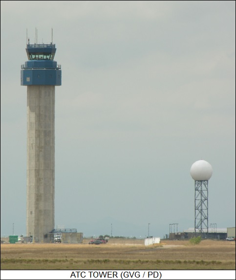
* The best-known aspect of air navigation is the air-traffic controller (ATC), well known from Hollywood airport epics. ATCs are usually associated with a control tower at an airport, though only a small number of ATCs actually work there. The ATCs in the tower handle all the incoming and outgoing traffic within line-of-sight -- of course, that's why they're in the tower. The bigger the airport, the need to keep an eye on more land area means a taller tower; at sprawling Denver International, the tower is almost a hundred meters tall. There's no one fixed design for towers; some of them are artistic in appearance, having been designed by internationally famous architects.
The "cab" at the top of the tower, where the ATCs work, has curved or downward-sloping glass to avoid glare, and there are arrays of blinds and sunscreens inside for the same reason. There's a "farm" of radio antennas on top -- not just for communicating with aircraft, but also for communicating with ground vehicles, such as fuel trucks, fire trucks, or snowplows. A radar antenna and the spinning green-white beacon may be sited on top of the tower as well.
Most of the ATCs at an airport track aircraft outside the line of sight with radar, and so these ATCs don't need to be in the tower, or even in a room with any windows. This control room may be underneath or near the tower, but there's no absolute reason to put the two in close proximity. The ground-level ATCs keep aircraft out of each other's way after takeoff and before landing.
In the USA, there are also about 20 ATC centers that are not associated with airports, being used instead to track cross-country traffic. These sites are hard to spot, being usually a cluster of nondescript government buildings, The only distinguishing feature is a tall tower fitted with a litter of radio antennas. Incidentally, air-traffic control radio chatter is in English over the entire world -- it's an international activity, and so the international language has to be used. It can be a bit startling to be watching, say, a Japanese movie and have the dialogue switch to English with Japanese subtitles when an aircrew starts talking with the ATCs.
* A typical airport also has a radar to keep tabs on traffic into and out of the airport. If the radar antenna is open to the air, you'll notice there are usually two antennas in the assembly -- one for the radar, one for the "identification friend or foe (IFF)" transponder on the aircraft. In the early days of radar during World War II, there was a problem in determining what blips on the radarscope were friendlies and which were hostiles. That led to the development of IFF systems, to allow friendlies to identify themselves. At first, the radar itself triggered the IFF system on the aircraft to provide an identifying signal, but as different types of radars operating in different bands proliferated, it became more sensible to use a separate, standardized "interrogator" system linked to the radar.
IFF sounds like a basically military technology, and that's where its roots lie. Civil aircraft use the same basic IFF transponder scheme as military aircraft. The system's not very useful if it's not standardized, since an aircraft with an IFF transponder built to one spec isn't going to respond to an IFF interrogator that is built to another -- meaning the aircraft is going to be marked as a possible hostile, not a healthy thing in a war zone. Military IFF systems do have more capability, including the ability to produce special variable IFF codes, since they have to prevent hostile aircraft from faking friendly IFF signals during time of war.
There are also large radar systems set up over the nation to keep track of air traffic. Since they have bigger antennas, they are usually housed in radomes because they would otherwise be vulnerable to heavy winds. [TO BE CONTINUED]
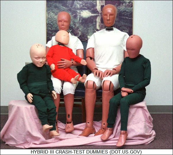
START | PREV | NEXT* CRASH-TEST DUMMIES: As discussed in an article in IEEE SPECTRUM ("Anatomy of a Crash-Test Dummy" by Erico Guizzo, October 2007) It doesn't take much thought to realize that a crash-test dummy is a more sophisticated piece of gear than a department-store manikin, but a close examination of exactly what goes into a crash-test dummy is still a surprise.
Welcome to Denton ATD, a 170-employee company with facilities in the states of Michigan and Ohio, founded by Robert A. Denton in 1969. The company's bread and butter is the "Hybrid III" dummy, or more formally "anthropomorphic test device" -- an inanimate model of a human being that helps determine, for example, how a human would respond to a car crash, and how to implement devices to improve passenger safety.
The Hybrid III consists of about 350 components, including a large number of components designed to simulate the elements of the human body. The parts are fabricated by Denton, from the vinyl skin to the metal bones. The neck is particularly complicated since the human neck is so prone to injury from collisions. The dummies are "wired" with sensors to track such items as the compression of the chest on a seat belt or the torque on the neck during a rapid deceleration. Researchers have "calibrated" the effects of such events using impact and deceleration tests on human cadavers, pig carcasses, and sometimes graduate students.
Denton didn't start out making dummies, instead originally manufacturing force and torque sensors, called "load cells", used in a wide range of equipment. A load cell is a relative of the strain gauge, which consists of a wire loop whose electrical resistance changes when the substrate it is mounted on undergoes strain. In the case of a load cell, the substrate is a small metal beam that deforms when stretched or compressed; a set of load cells can be mounted at different orientations to provide measurements along multiple axes. Denton still produces their own load cells; it's a nitpicking, painstaking job.
The Hybrid III not only features load cells, it also is fitted with accelerometers and potentiometers. Modern accelerometers are fabricated in silicon like microcircuit chips, but potentiometers are basically old-fashioned, being variable resistors in which an arm moving over the surface of a resistor measures deflection. All the components of a Hybrid III are carefully assembled to build a complete dummy. Ironically, before a crash-test dummy goes on to a life of torture, it must be tortured to ensure that it works properly, being beaten by machines until all is validated. The graduating dummy is awarded a certification stamp and packed away in a shipping container.
Hybrid IIIs are, not too surprisingly, available in a wide range of sizes. The most popular model is the "50th percentile male", which is 1.75 meters (5 feet 9 inches) tall -- or it would be that tall if it could stand up, but it can't -- and weighs 78 kilograms (172 pounds). It is designed to simulate an average North American male. There are models for larger and smaller males, a range of females, and a range of kids. The Denton catalog lists 40 different types of dummies and the company ships up to 25 dummies a month, mostly to the global automotive industries. The dummies are also used to test roller coasters, airplanes, helicopters, school buses, and anything else that can crash. A Denton official commented: "There were some applications where we had no clue what they were doing. It was proprietary or government-related. The dummies left brand-new, they came back in parts."
The specifications for the Hybrid III are not a secret. Anyone can obtain them from the US National Highway Traffic Safety Administration (NHTSA) as "Docket 71-14". The idea of the open spec is to ensure the consistency of safety standards -- in theory, a dummy from one company should be equivalent in terms of test results to another. Safety agencies elsewhere have much the same "open source" policy. Anyone could manufacture a Hybrid III dummy, except for the fact that it's not trivial to build. Denton has the experience and expertise to do a good job of it, and newcomers might find it hard to compete. In fact, Denton has only one competitor at its level of capability, First Technology Safety Systems of Plymouth, Michigan.
One of the other implications of this issue is that the specs for the dummy are frozen, and have been since 1972, when the US government issued the "Federal Motor Vehicle Safety Standard No. 208, Occupant Crash Protection". The origins of the act go back to just after World War II, when the US Air Force (USAF) was introducing ejection seats into combat aircraft. A USAF medical researcher named Colonel John Stapp pioneered bioresearch into the effects on humans of rapid acceleration and deceleration, with his work involving deceleration runs on rocket sleds. Stapp performed some of the test runs himself, with photostrips surviving of the contortions of his face, as well as images of the massive black eyes he suffered. An annual conference of car-crash testers, biomechanics researchers, and other safety industry officials is named the "Stapp Car Crash Conference" in his honor.
A range of other dummies were later developed by various industries. The aerospace industry produced the "Model T Parachute Dummy", "Torso", and "Dynamic Dan". The medical profession obtained "Rando for Radiotherapy", "Dexter Dental Dummy", and the "Phantom" family -- "Cardiac Chest Phantom", "Nuclear Phantom", and "Organ Scanning Phantom".
Car-crash test dummies were an outgrowth of public activism in the late 1960s and early 1970s that created pressure for safer vehicles. In 1971 General Motors (GM), which had been working on prototype dummies, decided to combine parts of two competing designs -- one from Alderson Research Labs and the other from Sierra Engineering. The result was the "Hybrid I" dummy. The Hybrid I of course led to the "Hybrid II" and the Hybrid III, which was built specifically for the NHTSA and was established by the agency as an official standard in the late 1970s. There was also the competing "Sierra" family -- "Sierra Sam", "Sierra Stan", "Sierra Susie", "Sierra Saul", little "Sierra Sammy", and "Sierra Toddler" -- which has now been retired.
There has been continued development of dummies, leading to the "Side-Impact Dummy (SID)" series: "SID", "EuroSID", "BioSID", and "WorldSID". As with the Hybrid series, the SIDs are government standards that are implemented by vendors such as Denton. WorldSID is regarded as the most advanced dummy now available. It was designed by a global consortium of industry, government, and academic experts, with the goal of harmonizing test protocols and safety standards. It can record 258 different measurements in a single test, and the pricetag can run to $350,000 USD -- more than twice as much as a Hybrid III.
Research is ongoing at automotive manufacturers, government agencies, and academic organizations to build even better dummies. Denton is working on a new sensor system called the "RibEye", in which each of a dummy's 12 ribs are fitted with a LED, with two light-tracking sensors on the dummy's spine. The RibEye can track the movement of the ribs in all three dimensions to 1 millimeter and is a great improvement over potentiometers.
The company is also involved in a project named "Facial & Ocular Countermeasure for Safety Headform (FOCUS)", working with the US Army Aeromedical Research Laboratory and the Center for Injury Biomechanics -- run jointly by Virginia Tech College of Engineering, in Blacksburg, and Wake Forest University School of Medicine, in Winston-Salem NC. The product of the effort is an improved dummy "face", with silicone-based eyeballs and a set of load cells arranged around the bones of the face. Given better protective armor for soldiers, eye injuries have become proportionally more common; the Army wants to obtain FOCUS to evaluate helmets, goggles, and vehicle protective features. FOCUS also has civilian applications, such as tests for airbag shock and sports injuries.
BACK_TO_TOP* CAR TALK: As reported in an article in BBC.com ("Connected Cars Promise Safer Roads" by Darren Waters) a global effort is now underway to provide cars with wi-fi "vehicle-to-vehicle" communications. The Europe-based "Car-2-Car (C2C)" consortium a collaboration of General Motors, Audi, BMW, Fiat, Honda, Renault, a number of automotive hardware manufacturers, and several universities -- envisions wireless communications between cars to inform other drivers if the car is slowing, braking, or changing lanes.
According to Professor Horst Wieker, from the department of telecommunications at the University of Applied Sciences, Saarbruck, Germany, said the aim is to create "foresighted driving". He said: "This technology allows us to build a short-range and long-range picture of road traffic conditions. You are aware of unseen danger around the corner and even many kilometers before you even encounter a hazardous situation."
The C2C effort is focused on developing industry standards for wi-fi communications between cars, there being no sense in different brands of cars having different communications protocols. The 2C2 system uses a wi-fi interface based on the IEEE 802.11p specification, with a direct range of 500 meters in open country and 100 meters in the city; it also features a Global Positioning System (GPS) satellite navigation system receiver, plus a central processor to coordinate the system. The central processor accepts inputs from the GPS receiver and the car's sensors -- which indicate speed, application of brakes, whether the car is rolling ahead or turning, whether windshield wipers are on, and so on -- while both listening to and contributing to wi-fi traffic. The communications transactions aren't just between cars driving near each other, either; important information can be relayed from car to car, even from cars driving in the opposite direction, to give a "bigger picture" of the traffic situation.
For example, if the system detects cars a few kilometers down the road all switching on their fog lamps, it will report that there is likely a fog bank ahead. It can also give alerts that emergency vehicles are approaching and that accidents have occurred ahead. Drivers are informed through an in-car display, audio alarms, and seat vibrations. The C2C group is working with ergonomic designers and industrial psychologists to determine the most effective schemes of providing alerts.
The ultimate system would not only involve car-to-car wi-fi communications, but also links to wi-fi systems operating from traffic lights and road signs, allowing a central traffic authority system to direct traffic away from congestion, road works, and accidents. The current effort is still in its early research phase, the consortium only recently having come to agreement on the proper wi-fi band to use -- not a trivial issue, since there's a considerable threat of communications interference. Work is underway towards a trial in Frankfurt, Germany, using 500 to 1,000 cars. However, nobody has given a roll-out date for delivery of the C2C specification.
* A related article from CNET.com talked about the whizzy gadgetry currently being implemented by auto manufacturers such as BMW, Mercedes, General Motors, and others. A recent survey of 2008 car models showed that 70% have a Bluetooth communications option, primarily for hands-free cellphone operation, and 80% have navigation systems, sometimes as standard. 60% have parking assistance features with audible warnings, and a third of them offer camera options to give the driver a view of what's going on in a car's blind spot.
There are concerns that all this snazzy technology may dangerously confuse drivers, with the worries having a clear basis in experience. In 2002, BMW introduced the "iDrive" system, which uses a click wheel along the lines of that of an iPod music player to scan through menu selections on an LCD display mounted high on the dashboard for controlling heating, air conditioning, navigation, and so on. The idea was that the iDrive would make driving safer, since the driver wouldn't have to fumble around to tinker with various controls scattered over the car.
The initial report was that it was much more distracting, being nicknamed "iCrash", with one critic saying: "It was crazy, just crazy. Disaster. You could customize everything. You could customize up to something like 700 variables." BMW engineers came to the conclusion that the idea was OK, it was the implementation that was flawed, and a better-thought-out, simpler implementation was introduced in 2005. One BMW official commented: "Because we were the pioneer, we came out with something that was a little too complicated for the first customer it was introduced to."
Other auto makers took the hint from BMW's troubles to come up with what they see as improved schemes. Volkswagen is working on voice input and output as an interface system. No matter what gimmicks are being introduced, however, the industry consensus is that, for the time being, vehicle automation does not mean putting the car in control: the automation is to help the driver, but the driver is still completely in charge.
BACK_TO_TOP* MISSION TO AN ASTEROID: Concepts for new US space strategies were discussed here last month, one of them being a crewed mission to an asteroid. As reported in AVIATION WEEK ("2025 Asteroid Landing Eyed" by Craig Covault, 21 January 2008), a team led by well-known planetary scientist Robert Farquhar has provided a detailed outline of a crewed asteroid mission -- a five-month mission to asteroid 99-A010 in 2025, with a month-long stay on the asteroid.
The mission would be based on the Orion Crew Exploration Vehicle (CEV) and the Ares I / Ares V boosters currently under development by the US National Aeronautics & Space Agency (NASA), though it would require new hardware as well. The CEV would be the core of a "Deep Space Shuttle (DSS)", which would be capable of supporting three or four crew for missions of up to 50 days without resupply. The DSS would have an enhanced chemical propulsion system using storable propellants, and would feature external tanks to provide fuel to get the vehicle out of the Earth's gravity well, with the external tanks then discarded.
The DSS would haul along a Bigelow-type habitat module in a "lander" configuration, but due to the slight gravity of the asteroid, the DSS would be able to land the habitat module on its own -- and then relocate it to support inspections of other regions of the asteroid. The mission would also haul along a small communications relay satellite to ensure that communications would be maintained even when the astronauts were on the "farside" of the asteroid relative to Earth.
The science haul from an asteroid could be impressive, since so little is known about the origin and history of these bodies. The surface work would be easier because the gravity on the asteroid is so slight, making it easier to move around, though the astronauts would have to be careful not to jump into orbit. The flight would be a superb rehearsal for a mission to the Martian moons Deimos and Phobos.
However, although the DSS would be suitable for missions to near-Earth asteroids with convenient trajectories and to the Earth-Sun L2 Lagrangian point, beyond Earth's orbit, it wouldn't have the boost or payload capability to make the trip to Mars itself. That capability would be provided by a reusable "Interplanetary Transfer Vehicle (ITV)", assembled at the L2 point from payloads lofted by multiple Ares V heavy-lift booster launches. The ITV would include a CEV, a crew module that could support up to six astronauts for three years, and an interplanetary propulsion system, possibly using a nuclear thermal rocket engine.
* A following article in the same issue of AVIATION WEEK discussed some of the political implications of the current American space plan, which envisions the US focusing on the Moon and Mars while defocusing on the International Space Station (ISS). This idea has made the foreign partners of NASA very nervous, since they staked heavily to get on board the ISS and aren't happy about the idea of being left holding the bag if the US decides to abandon the ISS effort.
Jacques Dordain, head of the European Space Agency (ESA), recently addressed these concerns in a meeting with NASA boss Michael Griffin. Griffin did what he could to reassure Dordain, pointing out that while there is no saying what policies the next US presidential administration will follow in space, there was no plan to abandon the ISS after 2015 -- the magic date currently floating around for when America will supposedly get off the ISS merry-go-round -- and nothing is being done to preclude the use of the ISS after 2015. Griffin pointed out that it was "unlikely that a future administration or Congress would decide to terminate a functional ISS solely because a particular date had been reached."
The ESA was making noises about developing a European free-flier facility -- a space station rigged to perform untended experiments, with periodic visits by astronauts -- if NASA made it clear the ISS had no future. Griffin's comments seemed to have reassured NASA's international partners. However, the ESA is very interested in developing its own crewed spaceflight capability, independent of both the US and Russia -- though there is no commitment to implementing such a capability at the present time.
BACK_TO_TOP* FLORIDA ROAD TRIP (17): After I reached I-70 in Kansas before noon on Monday, 25 September, there was nothing more to my road trip but to get back to Loveland. I went back through Denver on I-70, doglegged north on I-25 on I-207, and went on home. My schedule put me into Denver at Monday afternoon rush hour and I knew that in advance, but there was no way around it, and the jam wasn't as bad as I expected -- there was congestion going into I-207 and going out of I-207 (where it merges with I-25 is a nightmare, obviously prone to accidents) but otherwise I was little delayed. When I got back to Loveland I was tired, but nowhere near as tired as I thought I would be after an 11-day road trip -- I figured I'd be a wreck. The lawn wasn't in bad shape for not having been mowed, I had some laundry to do, but nothing that would be too much hassle.
Tallying up the expenses was relatively straightforward. I'd bought a "personal organizer" -- like a PDA but much cheaper -- at Walmart to track expenditures on the trip, particularly charge-card purchases of gas at service stations, and though I wasn't sure it would work out, it proved very useful, as long as I was disciplined in making sure I used it. It had a USB cable and I could hook it up to a "software emulator" on my PC to transfer all data. I could then dump the data to a comma-separated text file for import into a spreadsheet, arranging and crunching the data as I pleased. The USB hookup made it much more useful than it would have been otherwise.
I got to thinking about the potential of such a device. How about a similar unit at a similar price with a stripped-down Linux OS and applications written in Python? Those with the know-how could buy a developer kit and write their own apps. The real irony was that even at about $30 USD, such a machine would be more powerful, much more powerful, than an old Apple II PC -- 100 megabytes of ROM for the OS and apps would be easy, as well as a few megabytes of RAM and flash ROM for data and user apps.
Anyway, I came in well under budget for the trip. That was partly an artifact of budgeting generously, but even allowing for that, the trip was cheaper than I would have estimated, despite the fact that I'd bought a watch, flash drive and rain jacket. I'd covered about 7,500 kilometers (over 4,650 miles); picked up 1,075 raw pix (after tossing the obvious junk), which took four CD-ROMs to archive; and visited four theme parks, five zoos, and seven museums. It was a bit frantic to cram all that in to 11 days and if I'd known better I would have done things a bit differently, but I was caught in a bind -- how to see as much as I could without pushing myself too hard and spending more time on the road than I could spare or tolerate.
I found the best part of the trip to be Sea World Orlando, with the Naval Aviation Museum, Air Force Armaments Museum, Lowry Park Zoo in Tampa, and Disney Animal Kingdom on the second tier; the strict theme parks went a bit flat. This was the longest and most complicated trip I ever took, and likely ever will take.
And yet ... somehow as I was sorting through the pictures for this trip, I kept thinking about all the stuff that I wish I hadn't missed, and that it might be nice to do it again, this time forearmed with experience: spend a full day in Pensacola to get the flightline tour at the Naval Aviation Museum; visit Lowry Park Zoo again, skip Busch Gardens; hit Disney MGM and Animal Kingdom, skip the other theme parks in Orlando. No need to do Sea World again, I canvassed it pretty well ... hmm, there's a Central Florida Zoo in Sanford up the road from Orlando ... aw nuts, I know I'm going to back. [END OF SERIES]
START | PREV* INFRASTRUCTURE -- AVIATION (5): In the early days of cross-country air navigation, the only aids were visible -- town names painted on the roofs of buildings and the like, and beacon lights marking the way through mountain passes, sort of like lighthouses for the air. Flashing beacons still mark airports, with the beacons spinning to display two different colors of light: green and white at civil airports, double white at military airports, yellow and blue at seaplane airports.
In modern days, most navigational aids are radio based. The simplest is the "non-directional beacon (NDB)", which emits a distinctive signal, with a three-letter Morse code pattern that identifies the beacon location -- same as the airport code, usually, for example DIA for Denver International, LAX for Los Angeles International, and so on. A pilot can locate the beacon with a radio direction finder. All a radio direction finder amounts to is a loop antenna: a signal arriving perpendicular to the plane of the loop induces the same voltage all around the loop, resulting in no received signal, while a signal arriving in the plane of the loop induces a stronger voltage on one side of the loop than the other, providing a high received signal. Triangulating three NDBs will give the aircraft's location. An NDB ground station is typically a relatively small tower, possibly with an umbrella-like antenna on the top. Some high-power beacons may use a horizontal dipole, consisting of one or more lines strung between towers.
As noted, three NDBs are needed to obtain a position fix. There's a more sophisticated scheme, called "VHF Omnirange / Distance Measuring Equipment (VOR/DME)" that allows a position fix from one station. A VOR is a type of radio beacon, but unlike the NDB the VOR signal actually gives the compass direction to the beacon. The VOR broadcasts two signals, one that is fixed in phase and the other that shifts phase in a circle around the VOR. At compass north, the two signals are in phase; at compass south, the two are completely out of phase; and they are at intermediate phases at other angles. A VOR receiver can compare the two signals and return the compass direction to the VOR beacon.
That still isn't enough to determine aircraft location, since the pilot also has to have the range to the beacon. That's where DME comes in. A DME is called a "secondary radar". It works on the same principle as radar: send out a radio pulse and measure the time it takes for the echo to come back to determine the distance to the target. The problem with radar is that the radar system has to be able to pick up faint echoes and sort out the desired information from all the echoes returned. This not only requires a lot of expensive gear, it also means the radar gets echoes from everything in its line of sight, meaning it's hard to pick out a particular target on the ground and get the range to it.
DME gets around this problem by making the target cooperate. The DME unit on the aircraft sends out a pulse; the DME transponder on the VOR/DME picks up the pulse and sends back a high-powered response. No problem picking it up, it's like a loud shout compared to the faint echoes. Having both the compass direction and the range gives the position of the aircraft.
The VOR and DME units have little to do with each other except for the fact that they're located at the same beacon site; they don't even use the same frequency bands. The military found the VOR/DME scheme somewhat inconvenient, partly because of the dual bands, partly because a VOR/DME isn't very transportable and military forces often have to move around. As a result, the military came up with their own version of VOR/DME, called "Tactical Air Navigation (TACAN)". It uses exactly the same DME scheme as VOR/DME, but it includes a VOR equivalent that operates on the same frequency band as the DME.
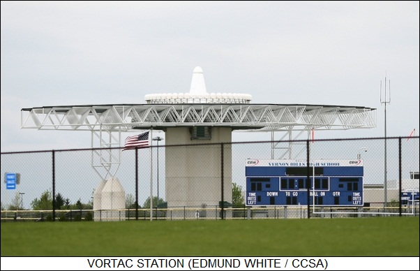
In some cases, a single beacon site may have both the civil and military VOR system along with the DME, in which case the beacon is called a "VOR/DME-TACAN" or in practice "VORTAC". A VOR/DME or a VORTAC station is distinctive, usually consisting of a small circular building with a cone on top that's usually compared to a witch's hat, though there are some cylindrical antennas as well. Traditionally, the phased VOR signal was generated by a rotating antenna, but more modern beacons use electronic steering -- usually indicated by a row of small antennas ringing the main antenna.
Thanks to the Global Positioning System (GPS) satellite navigation constellation, traditional radio air navigation aids are effectively obsolete. A GPS receiver on an aircraft can do a much better job than VOR/DME, providing more accuracy at lower cost; ground-based "augmentation systems" can be used to provide greater accuracy by transmitting corrections to GPS signals. The US and other nations are introducing a "Wide Area Augmentation System (WAAS)" to support cross-country air navigation, and there has been work on a more precise "Local Area Augmentation System (LAAS)" to replace ILS. However, LAAS development has proven troublesome. [TO BE CONTINUED]
START | PREV | NEXT* GIMMICKS & GADGETS: IEEE SPECTRUM reported on a "smart sheet" developed by researchers at the University of Tokyo. The concept is a sheet that could be laid out on a desktop to provide connectionless power and communications for devices set on it. The sheet contains antennas for transmitting power, with the antennas activated by pressure sensors on the sheet and power switched by organic transistors. Another set of components provides very short range wireless communications, using antennas and organic electronic components. The communications matrix in the sheet includes memories that indicate the proper communications route from one device to another.
Communications could be as high as 100 kilobits per second, not video rate but still good enough for file transfers. The short range of the wireless communications, amounting to a few millimeters, would help ensure security. All the organic electronic elements could be laid down by inkjet printing, resulting in a low-cost product.
* THE ECONOMIST had an interesting article on flexible, stretching electronic circuitry, seen as potentially useful for medical purposes -- bandages, body implants, and health monitors. This sounds on the face of it like a lead-in to a story about plastic electronic devices, but the idea requires nothing so leading-edge. IMEC, a Belgian research outfit, has developed a stretchable wiring system consisting of tracks of gold embedded in a silicone strip; the tracks are sinuous, along the lines of flattened springs, allowing them to expand or contract easily. The tracks also come in sets of four to give them redundancy in case one of the threads break. The technology can be implemented with techniques much like those used to implement rigid printed-circuit boards. IMEC has demonstrated a "stretchable watch" based on the flexible connection scheme, with standard (rigid) microchips mounted in the silicone. IMEC researchers are not satisfied with the configuration and are looking forward to incorporating chips in next-generation ultra-compact packages.
IMEC is working as part of a collaboration, the "Stretchable Electronics for Large Area Applications (STELLA)", whose other members include Dutch electronics giant Philips; Ergo, a French manufacturer of sticking plasters and bandages; and Finnish cellphone giant Nokia. Nokia researchers have come up with a scheme for depositing gold films on elastomeric polymers, in which the films have a matrix of tiny Y-shaped cracks that allow the gold to be stretched more without breaking. Nokia officials see "stretch circuits" as initially useful for touch screens and the like, but ultimately feel they could be used as sensors for body motions -- for example, a suit containing such sensors could be used to interact with a virtual-reality environment.
* The effort to replace old-fashioned illumination technologies with LEDs continues to gain momentum, with BUSINESS WEEK reporting on the efforts of Royal Philips Electronics to push the technology. Philips has spent billions of dollars to gain leadership in the lighting business, acquiring a number of lighting companies and setting up high-profile displays. During the holiday season, Saks 5th Avenue in New York City was decorated with 50 large white-LED snowflakes, with the total drawing about as much power as three toaster-ovens. The famous New Year's Eve Times Square Ball was replaced this year with a unit fitted with 9,500 Philips LEDs.
Philips seems to be outpacing rival General Electric in the lighting business, but GE is fighting back, having formed a partnership with Japanese LED maker Nichia; GE not only lit up the Rockefeller Center Christmas tree with LEDs, the company currently has a contract to replace fluorescent lighting with LEDs in 500 Walmart stores.
* According to an Associated Press report, Federal authorities are taking a keen interest in a new vending machine that has been installed in a number of locations in Los Angeles. The machine dispenses marijuana for medicinal purposes. The "prescription vending machine (PVM)" is choosy about who it sells to, however; purchases can be only made with a prepaid magstripe card, and a fingerprint is required to ensure that the proper owner of the card is making the purchase, or at least is present. A customer can only buy an ounce a week, with an eighth or a quarter of an ounce dispensed at one time.
Marijuana use is illegal under Federal law. The Federal government does not recognize the medical marijuana laws enacted in California and eleven other states. The Drug Enforcement Agency and other Federal agencies have been moving against medical marijuana dispensaries in California and slapping felony charges on their operators. One of the advantages of the machine is that it limits the number of workers who can get busted in a raid. One of the disadvantages is that pot-smokers usually like to inspect the product before they buy it.
BACK_TO_TOP* GIANT TOYOTA: As a Toyota fan, I was interested in an article in the 10 November 2007 issue of THE ECONOMIST titled "A Wobble On The Road To The Top". The article started talking about the fact that in 2007, Toyota is estimated to have finally surpassed General Motors (GM) as the world's biggest car-maker, selling 9.34 million vehicles to GM's 9.29 million.
Toyota managers downplay the rise to the top, saying that being the biggest isn't important, what is important is to do the best for the customer. Certainly crowing is not part of the company's list of 14 principles titled "The Toyota Way", but more importantly the company does not want to inflame American trade protectionism by drawing attention to GM's decline. Although Toyota builds much of the company's product for the US market stateside -- production quantities are ramping up to 2 million in 2010, more than half the number Toyota bosses expect to sell -- the company brass still doesn't want to step on toes.
The rise to the top is likely more important to Toyota executives than they want to admit publicly. They are even less eager to admit that the company's growth has had some pains. First, the famous "Toyota Production System" and its associated reputation for quality has suffered, leading to product recalls and a promise by the CEO of Toyota, 65-year-old Watanabe Katsuaki, to apologetically bow and promise to put the customer first. However, keeping such a massive production machine on track has proven difficult.
The second problem is that Toyota's reputation as a progressive "green" company, enhanced by its hybrid gas-electric Prius, has been eroding as critics point to Toyota products such as the new Tundra pickup, advertised as the "baddest, brawniest truck on the market". The new Lexus LS 600h luxury sedan, though a hybrid itself, is a big car whose fuel economy is nothing to write home about. Worse, Toyota teamed up with the "Big Three" American car-makers in Detroit to unsuccessfully oppose a bill in the US Senate that pushed automobile manufacturers to reach a not-too-painful fleet fuel economy average of 35 miles per gallon by 2020.
* Toyota has been in the car business for 70 years and has been selling cars in the USA for 50 of them. Toyota's sales keep rising steadily while those of the company's American competitors decline. Profit margins have been hefty, though as of late not as hefty as they have been, as the company invests in developing new models and building new factories. However, some of the investment has been to try to stop the erosion of Toyota's reputation for quality, with the company setting up new production controls, hiring more inspectors, and retraining workers to make sure they stay with the quality program.
The commitment to quality is obvious at the Toyota plant in Miyata, Japan, where production moves like efficient clockwork, workers call in managers if defects seem to appear, defects are carefully logged, and inspectors give the final product a careful looking-over before it goes out the door. They spot a defect in about one out of three machines, with the defect immediately fixed.
Toyota has also done a good job to make sure production standards are comparable in the company's overseas plants, which are mostly in the USA, the UK, and France. The key has been to send expert engineers, known as "senseis (teachers)", to spread the gospel. Four years ago, faced with the need to ramp up foreign production, the company established the "Global Production Center (GPC)" in Japan to turn out senseis in greater volume. The GPC has churned out 10,000 graduates, and branches are being set up overseas. However, there still haven't been enough senseis to go around. It isn't just the foreign "transplant" factories that have been suffering; there have been Toyota product recalls in Japan as well.
In 2006, the influential US magazine CONSUMER REPORTS dropped the Camry V6, the Lexus GS 4WD, and the Tundra pickup from its recommended list and said the magazine would no longer simply assume that Toyota products were reliable. On a survey of company reputation for reliability, Toyota came in fifth. Another consumer survey showed Honda outstripping Toyota for reliability. Toyota has downplayed the bad news, pointing out that quality is very high across manufacturers at the top end of the automotive industry, that the dings the company was hit for were minor, that CONSUMER REPORTS remains bullish on Toyota overall, and that the company is working hard to make sure the problems are just a temporary aberration.
The problem is that, with rapid growth, Toyota is having a hard time finding the talent needed to maintain the company's engineering culture, making it difficult to maintain standards. Company officials admit that they may just have to slow down expansion and make sure things are working right. They also have to work on the Toyota dealer network, which doesn't have a good reputation for handling customer problems.
* The weakening of Toyota's reputation for "greenness" is a longer term problem. The company promotes its hybrid technology, saying the plan is that 10% of sales will be hybrids by 2010 and almost all will be hybrids by 2020. However, at present the competition is moving fast to catch up. GM, Mercedes-Benz, and BMW are now introducing the "2-Mode" hybrid system, which is more effective with large vehicles than the Toyota "Synergy Drive" system.
Toyota has not been moving rapidly on development of a next-generation Prius, taking a conservative approach to the new lighter, faster-charging, lithium-ion batteries and preferring to stay with nickel-hydride batteries. In the meantime, GM is pushing towards commercial introduction of an advanced hybrid based on the Volt concept car, which will not only have lithium-ion batteries, but will be a much more efficient hybrid than the Prius. Anyone familiar with hybrid-car concepts immediately saw the Prius as a stopgap solution, a conventional car with an electric drive system tacked on; GM's solution is the one visionaries wanted all along, a purely electric-drive vehicle with an internal combustion engine used solely to charge up the electric system. This arrangement is lighter, simpler, cheaper, and more fuel-efficient.
Toyota seems to be thinking that GM's faith in lithium-ion technology may be misplaced, and that may turn out to be right. If it's not, GM may zoom forward of Toyota, and Toyota may have trouble catching back up. As mentioned, Toyota's reputation for "greenness" also suffered when the company opposed US fuel economy standards because it would make it hard to sell vehicles such as the Tundra pickup. Toyota is certain to become the world's biggest carmaker very soon. The challenge will be for the company not to lose its soul in doing so.
BACK_TO_TOP* Standards battles are not fun for either consumers or producers. Consumers are reluctant to get on board a new technology if it's not standard, since they may end up with gear that doesn't work with anything in a few years. Producers end up pumping money into promoting technology that isn't selling. However, sometimes people just can't agree on a spec and end up in a standards war.
That's been the case for two new video-disc standards, with the "High Definition DVD (HD-DVD)" standard group led by Toshiba battling it out with the "Blu-Ray" standard group led by Sony. HD-DVD offered about 15 GB of storage per side, while Blu-Ray offered about 25 GB per side. As reported in THE ECONOMIST ("Everything's Gone Blu", 12 January 2008), on 4 January Warner Brothers, which had been backing both formats, dropped support for HD-DVD. As one analyst put it: "Game over."
By late 2007, the number of Blu-Ray releases was outnumbering the number of titles released on HD-DVD by about two-to-one, and by the evidence of Blockbuster Video and Amazon.com offerings, the imbalance is now accelerating rapidly. Sony officials are no doubt feeling some satisfaction over their win, since they famously lost the videotape wars in the early 1980s, the Sony Betamax format being trounced by VHS. In part, Sony was able to prevail this time around because the company owns Columbia Studios and had shrewdly built a Blu-Ray drive into its Playstation 3 game console, stealthily creating an installed base of Blu-Ray players.
Among the big movie studios, only Paramount and Universal are still hanging on to HD-DVD. DVD sales have been declining as of late, and the financial pressure to get on a single next-generation video-disc bandwagon is intense. How long it's going to take Toshiba to throw in the towel is anybody's guess, but once it's obvious that they can't win, they'll have an immediate incentive to cut their losses.
* Not incidentally, it didn't take Toshiba very long to admit defeat. Following the Warner announcement, Best Buy announced that it would emphasize Blu-Ray, and the Netflix DVD rent-by-mail company announced that it would phase out HD-DVD. Walmart then announced it was dropping HD-DVD; Toshiba announced it was dropping the effort in mid-February.
The rapidly increasing proliferation of Blu-Ray titles suggests that in a few years, ordinary DVD is going to be hard to find at the rental store. I don't think buying a Blu-Ray player over the next few years is going to be troublesome, but what bothers me is the prospect of ending up with video players that won't read any of the old DVDs from my library. All current Blu-Ray players are DVD-compatible of course, and they are likely to stay that way for some time -- but if DVD disappears, sooner or later, so will backward compatibility.
[ED: As seen from 2015, there was no such worry. Blu-Ray was, if not quite a nonstarter, at least something of a yawn, since video downloads became the preferred method of video access. DVD continued to hang in there, simply on the basis of being the established, and perfectly adequate, technology. A user without an oversized TV, or watching fare that didn't really benefit from high-definition, doesn't need HD.]
BACK_TO_TOP* FLORIDA ROAD TRIP (16): On Sunday, 22 September, I left Alexandria, Louisiana, on a leg to Perry, Oklahoma -- I wasn't in too much of a hurry on the return trip because I knew by the route I was taking that it couldn't be reasonably done in two days. I was definitely showing signs of weariness, since as I drove into east Texas I was getting the nods, doing the "bobblehead", while I cruised down the freeway.
I turned north into Dallas and visited the city zoo, just off the freeway. It was definitely a worthwhile stop. There were two components to the zoo, one that was arranged as a fairly conventional midsized zoo, but then they added a second component on the other side of the freeway (connected by a pedestrian underpass) that had more modern displays of primates and the like. One of the really interesting features was a naked mole rat exhibit -- yet another Dawkins moment -- and I managed to get some good shots using the same camera-on-the-glass trick I'd figured out at Sea World.
They also had a nice bird enclosure, with a bunch of teenagers working as staffers; apparently they had some sort of high-school apprentice program. A cockatiel (parakeet-sized cockatoo) decided to roost on my shoulder for a few minutes, and I had the staffers get a shot of me with it. I was, however, disappointed that they didn't have an armadillo exhibit -- I'd never seen one elsewhere, and I would have bet that a Texas zoo would have to have armadillos. It was hot and sweaty that day, but the zoo was so interesting that it didn't bother me much. One of the better zoos I've ever seen, I give it five stars.
I cruised north through Oklahoma City -- I got sidetracked when I didn't notice that I had to take an exit ramp to stay on I-70, but it was an easy fix, just drive north and turn west on I-44 -- and reached Perry, Oklahoma, for my night stop. I was there in reasonable time and got a good night's sleep.
* Come morning on Monday, 23 September, I was on the road up into Kansas. I turned off the freeway at a truck stop after reaching the state to get breakfast at a McDonald's -- the McD's had an unusual feature, a big video display with a real-time weather map that had a web-page banner on it. I was puzzled for an instant, until I realized: twister warning system.
I cruised up through Wichita and decided to take a sidetrip to the local airport, not far off my track, in hopes of getting some interesting aircraft pix there. Wichita is a center for civil aircraft production, Cessna and so on, and it was my usual custom to visit municipal airports on trips anyway to see if there was anything interesting there. This side-trip was neither very time-consuming nor very profitable. While there were manufacturer's hangars at the airport, whether from accident or design (security for new products?) the flightline was walled off next to them, and all I got was a few shots of air freighters. I shrugged and drove on to my destination, the Cosmosphere space museum in Hutchinson, Kansas.
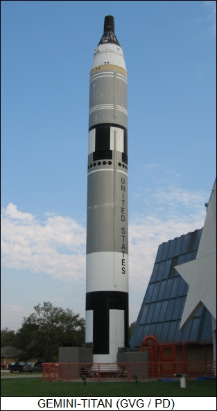
The Cosmosphere is a nice facility, with a Mercury-Redstone and a Gemini-Titan on display, and some fair interior exhibits. I got a few good pix, but it was nothing very special -- worth seeing, not worth going far out of one's way to see. I had the feeling that the thing had been backed by the local Chamber of Commerce to boost tourism. Oh well, the visit to the Dallas zoo made the trip back via Texas worthwhile.
I cruised north toward I-70 through the farmlands. My original plotting had specified a dogleg through Great Bend, but on rolling down the road I found the highways well-developed enough to make a straightline trip practical, and besides I was leery of speed traps in small towns; I spotted one on the way out of one town, glad I didn't run into it coming in, since I might not have slowed down fast enough to make the deputy happy. Getting busted would have been annoying enough; getting busted by people operating what amounted to a shakedown racket would have been really annoying.
I did get one benefit out of the sidetrip, in that I spotted a corn ethanol plant in the middle of the fields and stopped to get shots. I had been hoping to see one in Kansas, though I couldn't get close enough to get much in the way of detail. Not surprisingly, there was considerable construction activity on the site, I would bet to expand existing production capacity. I also got some nice pix of two very high-tech green John Deere farm combines sitting in the corner of a field -- they were in such clean shape and so neatly posed that I wondered if they hadn't been put there as a promotion for a local Deere distributor. [TO BE CONTINUED]
START | PREV | NEXT* INFRASTRUCTURE -- AVIATION (4): Since an aircraft may well have to land in night and bad weather, airports have extensive facilities to permit landings under almost all conditions.
Runways feature landing lights, which are embedded into the pavement. The lights are perfectly capable of tolerating the weight of a jetliner, though they do need to have tire rubber and the like cleaned off of them periodically. The centerline runway lights are spaced every 15 meters (50 feet); they're white up to 1,350 meters (3,000 feet) to the end of the runway, when they turn alternating red and white, and then go to all red at 450 meters (1,000 feet) from the end of the runway. There's also a strip of lights across each end of the runway -- lit green to mark the threshold of the runway for arrivals, lit red to mark the end of the runway for takeoffs.
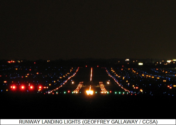
At the arrival end, there's a third system of lights running across the runway, consisting of about 30 rows with six lights each spaced 30 meters (100 feet) apart. They provide "roll guidance", giving the pilot a reference to permit keeping the wings level. Large airports generally have a fourth system of lights extending about 1,350 meters (3,000 feet) beyond the end of the runway, with sets of five lights mounted on tee poles spaced 30 meters (100 feet) apart. The lights are strobed to point into the threshold of the runway. The poles break off easily to yield to low-flying aircraft.
A fifth system, named the "visual approach slope indicator system (VASIS)", tells a pilot if the aircraft is on the proper approach angle, usually three degrees, using banks of lights straddling each side of the runway at 150 meters (500 feet) and 210 meters (700 feet) from the arrival threshold. The lights have special lenses and color filters that make them appear white at a high angle and red at a low angle. If both banks are white, the aircraft is too high; if both are red, the aircraft is too low; if the near or "downwind" banks are white and the far or "upwind" banks are red, the aircraft is on the right glide slope.
There are of course lights to mark the taxiways. Modern facilities have flush-mounted green lights down the taxiway centerline, but many older airports still have blue lights along the taxiway edge on short poles.
* Using lights for guidance is effective except when weather interferes, and then comparable radio landing systems take over. The radio-based "instrument landing system (ILS)" consists of two parts, a "localizer" system that ensures the aircraft is on the centerline, and a "glide slope" system that keeps it on the proper approach angle. The localizer system is marked by a set of antennas on the threshold of the runway; the aircraft gets a different signal when it strays to either side of the centerline, and is on the centerline when the ILS box in the cockpit says the two signals balance. The glide slope system is off to one side of the runway; it similarly gives a different signal if the aircraft is too high or too low.
There are also "marker beacons" to indicate the distance to the runway threshold, with each generating a fan-shaped radio beam that the approaching aircraft will fly through and get an indication. The "outer" marker is about 6.4 kilometers (4 miles) from the threshold; the "middle" marker is about 1,350 meters (3,000 feet) from the threshold; and the "inner" marker, which not all airports have, is only about 225 meters (750 feet) from the threshold. [TO BE CONTINUED]
START | PREV | NEXT